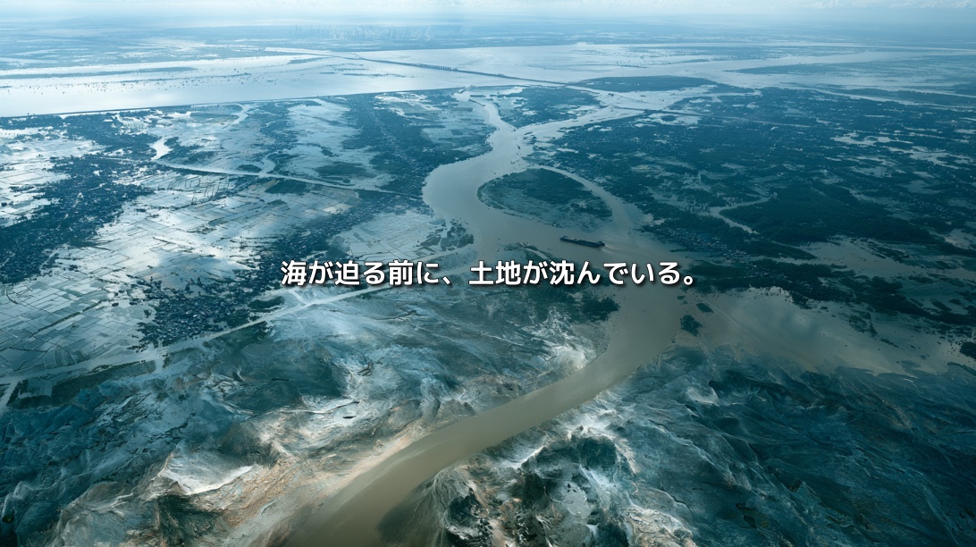
In southern Vietnam, land stretches across a shifting boundary between river and sea.
Countless waterways run between rice fields, orchards and aquaculture ponds, connecting villages to markets. During the rainy season, rivers swell. In the dry season, saltwater moves inland from the coast.
For the people of the Mekong Delta, water has long been both a threat and a source of land and food. Sediment carried from upstream settles and builds the ground. Floodwaters spread mud and nutrients across fields. Rivers deliver new material to the coast.
A delta is never finished. It persists because a river keeps carrying the material from which land is made.
Today, the Mekong Delta is sinking. Rising seas are part of the danger, but they are not the whole explanation. Groundwater extraction lowers the land. Dams trap sediment upstream. Sand is removed from riverbeds. Levees keep floods—and the sediment they carry—away from fields.
The ground is getting lower while the delta is losing the material that could help replenish it. The sea is not advancing on its own; human activity is also bringing the land closer to it. neoterrainjournal.com
A Delta Is Land the River Keeps Making
Rivers carry more than water. They move sand and mud eroded from mountains and riverbanks. Where a river slows near the sea, some of that material settles. Over long periods, these deposits create and maintain a delta.
The Mekong begins near the Tibetan Plateau and flows through or along China, Myanmar, Laos, Thailand and Cambodia before reaching the South China Sea through southern Vietnam. Places along the river are separated by thousands of kilometres, yet the movement of water and sediment connects them.
The ground beneath a farm in Vietnam may depend, in part, on material eroded far upstream. The Mekong Delta is therefore a landscape shaped by an entire international river basin. neoterrainjournal.com
On Average, Just 80 Centimetres Above Sea Level
The delta is exceptionally low and flat. A study published in 2019 used an improved elevation model and estimated the average elevation of the Vietnamese Mekong Delta at approximately 0.8 metres above sea level—around two metres lower than estimates previously used in international assessments.
That difference changes how future exposure to rising seas is understood. But elevation is not fixed. The sea is rising as the land itself subsides. Together, these processes increase relative sea-level rise: the change in sea level experienced from the surface of the land.
Rates vary across the delta and over time. At some locations, subsidence has been measured in centimetres per year—faster than the millimetres per year associated with global sea-level rise. Understanding the delta’s future requires measuring the height of the ground as well as the height of the sea. neoterrainjournal.com
Why Does Pumping Groundwater Make Land Sink?
Groundwater supplies homes, agriculture, aquaculture and industry across the delta.
Below the surface are layers of sand, clay and other sediments. Water fills spaces within those layers and helps support pressure in the ground. When groundwater is extracted faster than it is replenished, that pressure falls. Compressible layers, particularly clay, can compact. As they become thinner, the land surface sinks.
The process is not usually a matter of an empty underground chamber suddenly collapsing. It is the gradual compression of sediment. Once some layers have been strongly compacted, restoring the groundwater level may not restore their original thickness.
This creates a difficult cycle. Pumping groundwater can address an immediate water need, but subsidence makes flooding and saltwater intrusion more likely. If surface water then becomes harder to use, reliance on groundwater may grow further. neoterrainjournal.com
Subsidence Is Happening Now
Sea-level rise is often discussed over decades or a century. Subsidence is already changing conditions on the ground.
If the sea rises by a few millimetres each year while a particular area sinks by centimetres, the relationship between water and land changes much faster than a sea-level figure alone suggests. Roads may flood more readily. Drainage may take longer. The effective height of a levee can diminish as the land around it sinks.
Sea-level rise requires global action. Groundwater use, by comparison, is also shaped by decisions within the region. Treating every change in water level as an unavoidable consequence of climate change would obscure one of the causes that local policy can address. neoterrainjournal.com
Upstream Dams Can Leave the Delta Short of Sediment
A sinking delta can partly maintain its surface if rivers continue to deliver enough sediment. But that supply is under pressure.
Dams built for hydropower, irrigation and flood management hold back water—and capture sediment in their reservoirs. Some fine material continues downstream, while sand and coarser particles are often retained.
The benefits of electricity generation upstream and the costs of sediment loss downstream may fall on different communities and even different countries.
For a delta, sediment is not simply dirt that clouds the water. It helps build riverbanks and coastlines, nourishes floodplains and supplies material to tidal flats and mangroves. Water and sediment together have made the land. neoterrainjournal.com
Levees Stop Floodwater—and the Sediment It Carries
Levees, sluice gates and canals protect settlements and farmland. They have also supported more reliable agricultural production, including multiple rice crops each year.
Yet a flood confined to a river channel cannot spread its sediment across the floodplain. Historically, seasonal floodwater deposited a thin layer of mud on the land. Repeated over time, those deposits helped counter natural compaction and rising seas.
The answer is not to remove protection from places where people live. It is to consider where floods must be kept out and where water and sediment could be allowed to enter in a planned way.
Flood management in a delta is also a decision about the future movement of soil. neoterrainjournal.com
Construction Sand Is Disappearing From Riverbeds
Dams are not the only reason the delta has less sediment. Sand is extracted from the Mekong and its branches for construction.
As cities grow, demand rises for material used in buildings, roads, ports and other infrastructure. Removing sand can deepen a riverbed and alter the force of the current. Erosion may increase along nearby riverbeds and banks, threatening homes and farmland. A lower riverbed may also affect how far saltwater travels upstream during the dry season.
Research has raised concerns that actual sand extraction has exceeded official estimates in parts of the delta. Deltares describes a growing “sand debt”: more sand is being taken from the system than the river can replace.
Sand is renewable only if it arrives at least as quickly as it is removed. The sand already in a riverbed is a store of material delivered by the river in the past. neoterrainjournal.com
The Material Used to Build Cities Can Weaken a Delta
There is a tension at the heart of sand extraction. Sand from rivers helps make buildings, roads and raised ground. Removing it can also destabilize the riverbanks and beds that support other homes and fields.
That sand is not necessarily carried to distant cities. The delta itself needs construction material for its roads, levees and growing communities. A structure intended to reduce a local hazard may require material whose extraction creates risks elsewhere in the river system.
Built infrastructure and natural terrain are connected. The materials used to construct one place come from another. neoterrainjournal.com
Saltwater Moves Inland Quietly
During the dry season, lower river flows allow seawater to travel upstream. Salty water can damage rice and fruit crops. In some locations, groundwater extraction can also increase the vulnerability of aquifers to saltwater intrusion.
This is not only a problem at the shoreline. Salt can move inland through rivers, canals and underground layers. Because the delta is so flat, relatively small changes in flow and water level can alter how far it reaches.
Farmers are already adapting in different ways: changing planting seasons, storing freshwater or shifting from rice to brackish-water shrimp farming where conditions permit. Such changes require equipment, knowledge and capital. The options available to one household may not be available to another.
Environmental change does not affect everyone equally; the ability to respond is uneven too. neoterrainjournal.com
From Maximizing Rice Production to Living With Different Kinds of Water
The Mekong Delta is a major source of rice, fruit and aquatic products. For decades, policy and infrastructure have focused on increasing output: controlling floods, expanding irrigation, supporting multiple rice harvests and using groundwater during dry periods.
Those measures helped create high productivity. They also increased water demand and, in some places, interrupted the natural delivery of sediment.
The delta does not have one uniform water environment. Some areas have more reliable freshwater; others experience seasonal salinity; coastal areas live with a stronger marine influence. Crops, aquaculture and land use can be adapted to those different conditions.
The long-term question is how to build a productive region that can also withstand changing water and land levels. neoterrainjournal.com
Protecting Land Means Allowing Sediment to Move
Stronger levees and raised roads will be necessary in some places. But structures alone cannot maintain an entire delta indefinitely if its land-building processes continue to weaken.
A broader response would include reducing excessive groundwater pumping, expanding reliable water supplies, examining ways for dams to pass more sediment, limiting harmful sand extraction, and preserving places where floods can deposit mud. Restoring mangroves and tidal flats can also help protect vulnerable coasts where conditions allow.
These actions are connected. They concern whether water and sediment can still move from the upper river to its floodplains and coastline. neoterrainjournal.com
Removing Every Dam Would Not Solve the Problem
Dams provide electricity and economic benefits. Sand extraction supports construction and jobs. Groundwater remains essential where safe piped water is unavailable. Their effects cannot be addressed by pretending these needs do not exist.
The harder issue is that benefits and costs appear in different places and at different times. Hydropower can bring revenue upstream today, while sediment shortages accumulate downstream. Groundwater meets a need now, while subsidence emerges over years. Sand builds today’s roads while reducing material available to sustain tomorrow’s riverbanks.
Delta management requires these near-term benefits and long-term costs to be considered in the same decisions. neoterrainjournal.com
One Country Cannot Protect the Mekong Delta Alone
The Mekong crosses national boundaries. Dams, tributaries and land use upstream affect the water and sediment delivered downstream, while each country has its own energy and development priorities.
Vietnam can improve groundwater management and regulate sand mining within the delta. Yet if the upstream sediment supply continues to fall, local action alone cannot fully restore the delta’s ability to build land.
Cooperation must therefore address sediment as well as water. How much material does each dam retain? When can water and sediment be released? How should downstream losses to farming, fisheries and land be assessed?
Sharing a river means sharing more than its flow. It also means making decisions about the material from which future land is formed. neoterrainjournal.com
Looking Only at Sea-Level Rise Misses Part of the Problem
Describing the Mekong Delta as a place threatened by climate-driven sea-level rise is accurate, but incomplete.
Groundwater policy can influence subsidence. Dam management and sand extraction can influence sediment supply. Floodplain design can determine where mud is deposited. Mangrove restoration may strengthen parts of the coast.
Climate change matters greatly. Human decisions about water, sand and flood control also affect how vulnerable the delta becomes to it. Recognizing those decisions makes room for action. neoterrainjournal.com
More Than the Ground Is Sinking
The delta exists because the Mekong has carried sediment toward the sea for generations.
Each intervention has a reason: dams produce electricity; groundwater supplies water; sand builds infrastructure; levees protect people and crops. Taken together across the river basin, however, these choices can weaken the processes that sustain the land itself.
The challenge is how decisions are made across distance and time—between upstream and downstream, city and countryside, present benefits and future losses.
It may appear that the sea alone is taking the land. First, we need to understand how the land’s ability to maintain itself has been reduced. neoterrainjournal.com
References
- Nature Communications, “Mekong delta much lower than previously assumed in sea-level rise impact assessments”
- Environmental Research Letters, “Impacts of 25 years of groundwater extraction on subsidence in the Mekong delta, Vietnam”
- Scientific Reports, “Sand mining in the Mekong Delta revisited”
- Oceanography, “Sedimentation and Survival of the Mekong Delta”
- Deltares, “Uncovering the Mekong Sand Debt”