How the sea, the opening of the port, and generations of rebuilding shaped a city between two shores
NEOTERRAIN Journal | Intellectual Travel | Hakodate, Hokkaido
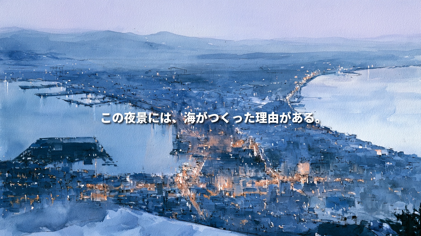
After sunset, the sea darkens on both sides of the city.
As the last blue fades from the sky and the outlines of buildings disappear, the lights begin to draw a shape of their own.
The city narrows close to the mountain, then fans out into the distance. On either side lies a dark expanse of water.
This is the night view from Mount Hakodate.
You may recognize it from a photograph. Yet its shape leaves a simple question.
Why did a city grow on such a narrow strip of land?
Follow that question, and the view begins to reveal several histories at once. The sea laid down the ground. Ships brought people and goods. And after fires swept through the city, people decided how to build it again. neoterrainjournal.com
01 | The Sea Laid the Ground Beneath the Lights
Mount Hakodate was once an island.
Over time, a sandbar grew between the island and the main island of Hokkaido, joining the two. Geographers call a sandbar that connects an island to the mainland a tombolo. Mount Hakodate is a classic example of an island attached to the mainland in this way. 国土地理院
From the summit, you can see Hakodate Bay on one side and the coast facing the Tsugaru Strait on the other. The land between them gives the city its distinctive waist.
At night, the dark water makes the edges of the illuminated city stand out. What looks at first like a pattern of lights is also the outline of two shorelines.
In daylight, you can trace the boundary between land and sea. You can see where the city narrows and where the harbor sits inside the bay. As dusk falls, those same contours become an outline drawn in light.
Arrive before sunset and stay until dark. The shape you saw on a map becomes the night view before your eyes.
02 | The Port Drew People to the City
The sea helped form the land. The port gave people a reason to gather there.
Hakodate’s harbor lies along the curving shoreline at the foot of the mountain. During the Edo period, it became an important center for collecting seafood and shipping it to Honshu. The merchant Takadaya Kahei helped develop that trade. はこぶら
Think of what it took for a ship to unload and set sail again. Someone had to receive the cargo. There had to be somewhere to store it. People set prices, arranged sales, and sent goods on to their next destination. Ships needed provisions for the voyage ahead.
Traffic at sea created work on land.
Walk through Hakodate and look at the buildings on the slopes and the warehouses at the water’s edge. Between them ran the daily journeys of people going to work, doing business, and returning home.
03 | Opening the Port Changed Who Met Whom
Hakodate opened to foreign ships in two stages. In 1855, it began providing supplies such as firewood, water, and food. In 1859, it opened to international trade. Foreign merchants and consuls became part of the life of the city. はこぶら
Walk through Motomachi today, and the churches and Western-style buildings catch your eye. Hakodate’s ties to distant countries took an architectural form that still stands.
Imagine the everyday encounters behind those buildings. Making a deal in a language you were hearing for the first time. Living alongside people whose customs were unfamiliar. Working out what a shipment or a piece of news was worth to someone who saw things differently.
Opening the port changed the rules of trade. It also brought people into relationships they had never had before.
For those who came to live and work here, what did the harbor look like from the other side of a window?
04 | Why Did Churches and Consulates Rise Above the Harbor?
You might expect institutions with ties to the port to cluster along the waterfront. Yet several of Hakodate’s churches and former consulates stand uphill in Motomachi.
After the port opened, foreign consuls and merchants often chose sites partway up Mount Hakodate, with views over the harbor, over the waterfront settlement the shogunate had set aside for them. Consulates, churches, and religious schools helped shape the district that survives today. はこぶら
Living close to the harbor offered one advantage. Being able to look out over it offered another.
As you climb, the sea appears between buildings. With each turn, the relationship between the hillside and the waterfront becomes clearer.
From the top of Hachimanzaka, your eye follows the straight road down to the harbor. Take a moment to look at the houses on either side. People went down this slope to work and climbed it again to get home.
At the end of the road, there was always the sea.
05 | The Wide Streets Remember the Fires
On a walk through Hakodate, pay attention to the width of the streets.
Nijukkenzaka takes its name from its width of twenty ken, about 36 meters. The city laid out the broad slope after the great fire of 1879 to help slow the spread of future fires. はこぶら
Today, that width opens up the view. It also tells us something about what people lost.
Hakodate suffered repeated major fires. After the great fire of 1934, the city incorporated broad roads and planted greenbelts into its reconstruction to act as firebreaks. The shape of modern Hakodate bears the marks of both its prosperity as a port and its efforts to rebuild. archives.c.fun.ac.jp
Some of Motomachi’s churches and former consulates were themselves rebuilt after fires. When you cross a wide street or look up from the paving stones, you can see the choices people made about what to build again and how to keep the next fire from spreading. はこぶら
06 | Begin the Night View with a Walk in Daylight
Before going up Mount Hakodate, spend some time walking through the city below.
At the waterfront, notice how close the harbor is to the streets. In Motomachi, climb the slopes and see where the churches and Western-style houses stand. At Nijukkenzaka, cross the broad road and think about why the city needed so much space there.
Then go up the mountain.
From the summit, the places you walked through settle into the larger geography. The slope you just climbed. The buildings along the shore. The broad road. The city spreading out beyond them.
As darkness falls, those places gradually become points of light.
Somewhere below, people are finishing work, heading home, or looking after the buildings that hold the city together.
On ground shaped by the sea, it is their ordinary evening that lights up the view.
Editor’s Note — NEOTERRAIN
What first caught my attention about Hakodate’s night view was the way it narrows in the middle.
That detail led me to the story of a mountain that was once an island. From there, I began to notice where people chose to live after the port opened and why the city laid out some of its streets so wide after the fires.
A single photograph holds all these different spans of time. The years it took the sea to build up the land. The generations over which the port changed the city. The few minutes it takes someone to get home and switch on a light.
Knowing a little of that history makes it easier to imagine the people behind those distant lights.
When a view makes us stop, it can be worth asking how it came to look that way. The question can draw us closer to the people who live there now, as well as to the people who came before them.
In Hakodate, I’d like to walk the city in daylight first, then see how the streets I’ve walked begin to glow.
References and Further Reading
- Geospatial Information Authority of Japan — Coastal Landforms, Including Tombolos
- Hakobura — The Hakodate Magistrate’s Office and the Opening of the Port
- Hakobura — Motomachi’s Hillside District
- Hakobura — Hakodate’s Slopes and the History of Its Great Fires
- History of Hakodate — Great Fires and the Urban Landscape
- Japan Travel Bureau Foundation — The Night View from Mount Hakodate
This article draws on published sources. The opening and other descriptive scenes are illustrative.