Beyond the “90% Shrine” Headline: A Changing Lake and the Lives Around It
Lake Chad lies near the southern edge of the Sahara, where Chad, Nigeria, Niger, and Cameroon meet.
It is often described as a lake that has lost 90% of its area to climate change. Satellite images showing a vast expanse of water contracting into smaller patches have become a familiar symbol of environmental crisis.
But Lake Chad is not simply shrinking in one direction toward disappearance.
Its water moves across an exceptionally shallow landscape. As it rises and falls, the boundaries of farmland, fishing grounds, pasture, and settlements move with it. For people who live around the lake, the crisis is about more than how much water remains. It is also about when and where that water will be. neoterrainjournal.com
A Shallow Lake With No Outlet to the Sea
Lake Chad is an inland lake with no river carrying its water to the ocean. Water leaves mainly through evaporation and infiltration into the ground. Changes in rainfall and river inflow can therefore have a strong effect on its extent.
The lake is also remarkably shallow, with an average depth of only a few metres. In a deep basin, a change in water volume may move the shoreline only a little. On a broad, flat surface, the same change can shift it a long way.
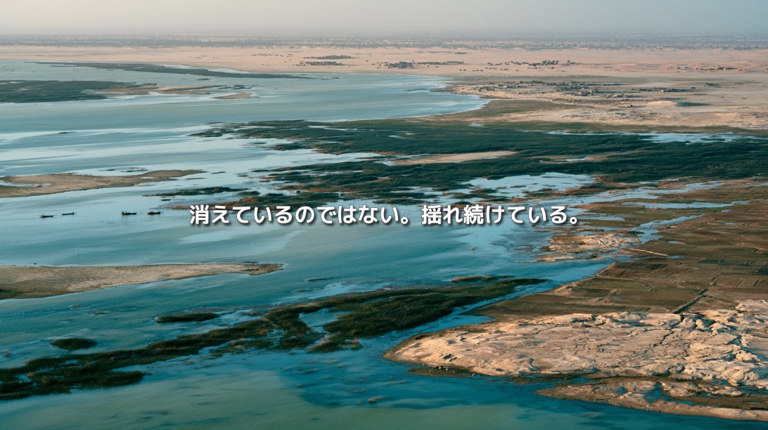
Lake Chad behaves less like a reservoir and more like an immense wetland spread across low-lying land. When water rises, large areas flood. When it recedes, grassland and fields can emerge from the lakebed.
Its boundary cannot be fixed as a single line on a map.
The “90% Shrinkage” Figure Has a Basis
In the 1960s, Lake Chad’s surface area is estimated to have reached roughly 25,000 square kilometres. Severe drought struck the Sahel in the 1970s and 1980s. Flows in the Chari–Logone river system, the lake’s principal source of water, declined, and the lake separated into northern and southern basins.
Water withdrawals for agriculture, growing demand from a rising population, and changes in land use added pressure. Measured by its open water, the lake contracted to a fraction of its former extent.
That history is real. Yet the comparison needs care.
The 1960s were an unusually high-water period. Estimates also differ depending on whether they count only visible open water or include flooded areas covered by aquatic vegetation. A satellite image of blue water does not necessarily show the full extent of a lake and wetland system.
Before comparing “then” and “now,” we need to know what was measured in each period.
In Recent Decades, the Lake Has Not Only Shrunk
Research using satellite observations has shown that, since the 2000s, Lake Chad has not continued to contract steadily. Its water area and volume fluctuate and can recover seasonally.
The southern basin has been relatively stable, while the northern basin varies much more from year to year. Extensive wetlands covered by aquatic vegetation surround the open water.
Lake Chad is therefore better understood as a lake and wetland system that underwent a major historical contraction and continues to change dramatically.
This does not mean its environmental problems are over. It means that people must cope with a moving shoreline as well as the legacy of past water loss.
When Water Recedes, Land Appears
As the lake withdraws, it reveals moist, nutrient-rich ground. Communities have long practised flood recession farming, planting crops on land left behind by retreating water.
A fisher may begin farming. A herder may bring livestock onto newly exposed grassland. The retreating lake can appear to create new opportunities.
But the new land has not permanently become dry land. A wetter season may put it underwater again.
A field can become part of the lake. A fishing ground can become pasture. Work, movement, and access to resources must adjust to the changing boundary between water and land.
Returning Water Can Also Be a Disaster
When we hear that a lake is in crisis, we often imagine water disappearing. For someone living or farming on land that has been dry for years, the return of water can mean a flood.
Crops may be submerged. Livestock routes may be cut off. Fishers, farmers, and herders may find themselves using the same areas, creating friction over land and water.
Climate change does not necessarily push Lake Chad toward dryness every year. Higher temperatures can increase evaporation, while some years also bring heavy rainfall and flooding.
The challenge is not captured by an average water level alone. It lies in the scale and timing of the changes—and in how difficult they are to anticipate.
Water Changes Across Borders
More than 45 million people across the Lake Chad basin rely on its resources and surrounding landscapes for agriculture, fishing, herding, and trade.
The rivers that feed the lake cross political boundaries. The Chari–Logone system supplies the great majority of its inflow from the south. Water withdrawals or land-use changes upstream can affect shorelines and fisheries far away.
More irrigation in one area may reduce the water reaching another. Degraded soils upstream can add sediment to rivers, changing channels and wetlands downstream.
No single country can manage the lake’s future alone. Lake Chad is a shared water system whose changes reach across borders.
Environmental Change Does Not Explain Conflict by Itself
The Lake Chad region faces overlapping challenges, including armed violence, poverty, food insecurity, and displacement. These are sometimes reduced to a simple claim: the lake shrank, so conflict followed.
Environmental change does not automatically produce violence. Limited public services, scarce employment, political and historical tensions, border governance, and insecurity also shape what happens.
Pressure on land and water can deepen vulnerabilities that already exist. Treating the lake only as a security issue, however, can obscure the everyday histories of farming, fishing, trade, and movement along its shores.
The people who live with the lake need more than a single explanation for their circumstances.
Restoration Means More Than Making the Lake Bigger
Large projects to bring water into Lake Chad from another basin have been discussed for years. Yet expanding the water surface would not solve every problem.
Land currently used for crops or settlements could be flooded. A transfer canal could affect the ecosystems and communities of the river basin supplying the water.
The goal cannot be to hold a naturally variable lake at one fixed size. People also need ways to live with its changes.
That means combining satellite observations with local measurements to anticipate water levels, warning communities before floods, improving water use in agriculture, managing fisheries, protecting livestock routes and wetlands, and agreeing on water rules across borders.
Efforts launched by the Lake Chad Basin Commission and the African Development Bank in 2026 likewise place importance on monitoring, regional cooperation, ecosystem recovery, and the ability of communities to adapt—not merely on increasing the area of open water.
The Crisis Is Losing the Ability to Plan Ahead
Lake Chad has not simply disappeared. It contracted dramatically in the past and continues to change shape with seasons and rainfall.
For the people around it, knowing that water exists is not enough. They need to know when it will arrive, where it will spread, and how long it will stay.
When the shoreline moves, the location of work changes. When water returns, claims to land may change. When a river is used differently upstream, lives across a border may change too.
Lake Chad shows us that a lake’s crisis cannot be measured only by the loss of open water. It emerges when the pace and uncertainty of environmental change exceed people’s ability to adapt.